Construction industry
To us, surveying in the construction industry, means professional competence, commitment and flexibility. We meet these requirements by employing 40 people, having over 25 years of experience and by using state-of-the-art technology. Our application area extends all over Germany.
BIM-services
- BIM-to-field
- Scan-to-BIM
Services:
- Stake-outs
- As-built-documentation
- Inventory- and as- built documentation
- Control- and monitoring measurements
- Quantity survey and quantity takeoff
- Surveying during planning phase
- Special services

Our top reference for construction industry
B10/ B14 connection at the Leuze-Tunnel (the cut-and-cover technique) B10 – Rosensteintunnel – (the cut-and-cover technique and the mining technique)
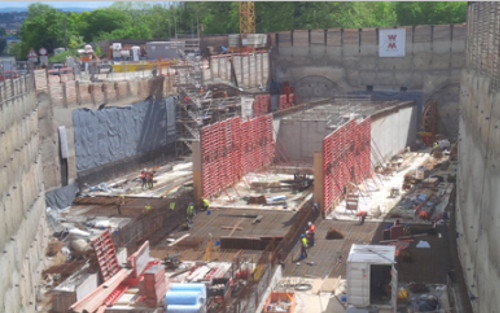
Object
Federal motorway A5 Malsch – Offenburg – Public Private Partnership (PPP), kilometre 657,00 – 701,5 B10/ B14 connection at the Leuze-Tunnel (the cut-and-cover technique) B10 – Rosensteintunnel – (the cut-and-cover technique and the mining technique)
Extent
construction survey, control measurements, as-built survey
Software
Geograf, CARD/1, Caplan
Instruments
Tachymeter : Leica 1203/ Leica MS 50
Digital level: Leica DNA 03
Detailed service description
• Assumption of the control points provided by the client and its full compaction and equalization
• Survey of original terrain
• Regular review of the control points located in the general control network
• Assumption and preparation of data resulting from the stake out plans provided by the client
• Pegging of building, timbering and building pit
• Affixing of axes points and stake out points
• Creating height reference points (adhesive label or bolts)
• Installing of crack heights in all business premises
• Surveying for building planning of areas suspected to be contaminated
• Installation of various measuring bolts
• Deformation measurement on shoring girders
• Control measurement of settlement bolts on the buildings
• Preservation of evidence of supporting bolts
• Quantity takeoff


